
Snake River Rampdown from Jackson Lake Dam:
Drone Imagery Analysis of Channel Isolation
The 2021 rampdown of flows from Jackson Lake Dam garnered attention from anglers, recreators, agency partners, and members of the public due to its large magnitude and relatively short duration. This report summarizes the 2021 rampdown of flows from Jackson Lake and its effects on the Snake River downstream.
The report aims to provide baseline information on changes to surface area and channel connection, as a proxy for changes in available aquatic habitat on the Snake River during the rampdown. This report was a result of the partnership between Teton Conservation District and Trout Unlimited.
In support of continuing conversations between agency partners and the Bureau of Reclamation, Teton Conservation District hopes to provide data-based evidence of how the Snake River’s fishery habitat changes with decreasing flows. Instream flow studies were initially completed by Wyoming Game and Fish Department staff in 1987 and 1989, but only a few studies have attempted to address this portion of the Snake River’s flow dynamics since that time.

The Study Area for the Snake River Rampdown from Jackson Lake Dam Technical Report.
Study Area
The study area for this report encompassed a 3-mile section of the Snake River, centered on the Wilson Bridge. This section of the Snake River was chosen because it is easily accessible and allows drone imagery collection, unlike sections closer to the dam within Grand Teton National Park where drone use is prohibited.
Trout Unlimited staff member Matt Barney operated a drone daily between October 1-5, 2021, to capture images of the Snake River at changing flows during the rampdown. Teton Conservation District staff stitched together these images into five daily mosaic images, which were analyzed to quantify surface area and channel changes during the rampdown.

Matt Barney (Trout Unlimited) operates a drone above the Snake River in October 2021.
A drone test flight before capturing imagery on October 4, 2021.
Results
Between October 1 and October 5, 2021, flows from Jackson Lake Dam decreased from 2,100 cubic feet per second (cfs) to 240 cfs. During that same period, the Snake River within the study area lost 23% of its connected surface area, or the total area that is connected to the Snake River’s main stem. The largest daily decrease in surface area observed during the study occurred between October 1 and October 2, where the Snake River lost 8% of its surface area. A total of eight side channels lost complete connectivity with the main stem of the Snake River, and five of those eight channels lost connectivity between October 1 and October 2.
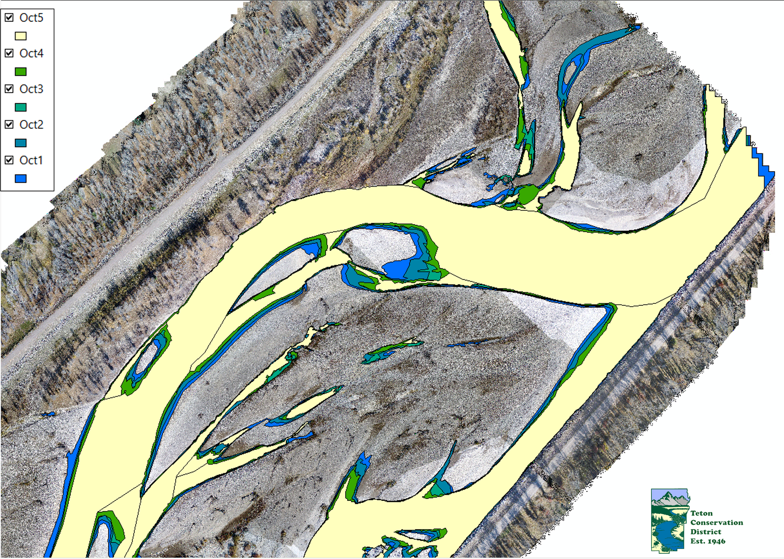
An image of the dataset used to analyze channel change in the Snake River study area. Image courtesy of Teton Conservation District.
Generally, measured surface area decreased with discharge at a linear rate, but there was a deviation from this linear relationship between 1,270 and 1,060 cubic feet per second (cfs), implying that fisheries habitat may be more susceptible to changes in this range in flows. Previous studies by Wyoming Game and Fish suggest a similar range in flows is recommended for maintaining fisheries habitat in the Snake River below Jackson Lake Dam.
Teton Conservation District presented these and other findings to agency partners and the Bureau of Reclamation in May 2023. Teton Conservation District along with these agency and nonprofit partners are working together to support additional studies, beginning in summer 2023, by researchers at Idaho State University who aim to study the biology and geomorphology of the Snake River below Jackson Lake Dam.